Please log in to see the coordinates.
                                Please log in to see the coordinates.                            
         Altitude: 176 m. ASL.
                Altitude: 176 m. ASL.
             Region:
                
                  Poland > pomorskie
 Region:
                
                  Poland > pomorskie                
             Cache type: Traditional
                Cache type: Traditional
             Size: Regular
                Size: Regular
             Status:
                                  
                                      Archived
                Status:
                                  
                                      Archived                  
             Time required:
                                            0:05 h
                    Time required:
                                            0:05 h                                          
                     Distance to travel:
                                            n/a
                    Distance to travel:
                                            n/a                    
                 Date hidden: 20-07-2013
                    Date hidden: 20-07-2013                             Date created: 20-07-2013
                Date created: 20-07-2013             Date published: 20-07-2013
                Date published: 20-07-2013             Last modification: 29-08-2014
                Last modification: 29-08-2014             34x Found
                        34x Found                     3x Not found
                        3x Not found                     1 notes
                    1 notes                 0 watchers
                    0 watchers                 7 visitors
                    7 visitors                 23 x rated
                    23 x rated                 Rated as: Good
                    Rated as: Good
                 1 x recommended
                            1 x recommended                        
                         Cache attributes
            Cache attributes


 Description


                            PL
        Description


                            PL
                        
            
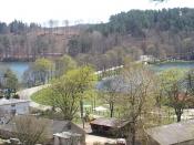
        Brama Kaszubska to wąski przesmyk łączący Jezioro Raduńskie Górne z Dolnym. Leży na końcu leśnego wąwozu, w którym biegnie droga wojewódzka nr 228 łącząca Kartuzy z Bytowem. Na wysokości przesmyku droga biegnie dalej przez około 300m wąską malowniczą groblą pomiędzy jeziorami. Tuż obok przebiega czarny Szlak Wzgórz Szymbarskich, wodą zaś biegnie (a może raczej płynie) trasa turystyczna wodniaków zwana "Kółkiem Raduńskim".
Można się tutaj zatem dostać pieszo, rowerem, kajakiem, lub zupełnie banalnie samochodem. Jadąc autem od strony Kartuz 20m przed przesmykiem po lewej stronie znajduje się mały leśny parking.
Dodatkowe informacje o szlakach znajdziecie tu:
O skrzynce:
 Additional hints
            Additional hints
        
     Pictures
            Pictures
        
     Log entries:
        Log entries:
        
             34x
            34x
             3x
            3x
        
         1x
        1x