Największy na świecie niekomercyjny serwis geocachingowy
GeoŚcieżki - skupiające wiele keszy
Ponad 1000 GeoŚcieżek w Polsce!
Pełne statystyki, GPXy, wszystko za darmo!
Powiadomienia mailem o nowych keszach i logach
Centrum Obsługi Geokeszera wybierane przez Społeczność
100% funkcjonalności dostępne bezpłatnie
Przyjazne zasady publikacji keszy
Show cache statistics
Szczyty Gminy Nowy Tomyśl [RONT] - OP9F7U
This cache belongs to GeoPath!
![](/images/blue/kompas.png)
Please log in to see the coordinates.
![](images/free_icons/mountain.png)
Altitude: m. ASL.
![](images/free_icons/world.png)
Region:
Poland > wielkopolskie
![](images/free_icons/box.png)
Cache type:
Traditional
![](images/free_icons/package_green.png)
Size:
Small
![](images/free_icons/page.png)
Status:
Temporarily Unavailable
![](images/free_icons/date.png)
Date hidden: 08-09-2021
![](images/free_icons/date.png)
Date created: 08-09-2021
![](images/free_icons/date.png)
Date published: 10-09-2021
![](images/free_icons/date.png)
Last modification: 26-12-2023
![](images/log/16x16-found.png)
16x Found
![](images/log/16x16-dnf.png)
1x Not found
![](images/log/16x16-note.png)
0 notes
1 watchers
![](images/free_icons/vcard.png)
28 visitors
![](images/free_icons/thumb_up.png)
10 x rated
![](images/cache-rate.png)
Rated as:
Excellent
In order to view coordinates and
the map of caches
you must be
logged in
Cache attributes
Description
PL
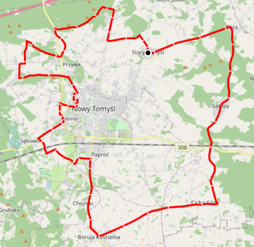
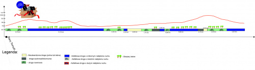
Długość: 42 kilometry
Ścieżki rowerowe: 12,90 km
lokalne drogi asfaltowe: 23,60
drogi polne: 3,40 km
szutry : 2,10 km
![](https://images91.fotosik.pl/524/b596700c095872f2med.png)
Pobierz plik GPX
![](https://images89.fotosik.pl/526/022c5f676f8f3167med.jpg)
Additional hints
You must be logged-in to see additional hints
Log entries:
16x
1x
0x
1x
All entries
Gallery