

Zobacz statystykę skrzynki
 Zaloguj się, by zobaczyć współrzędne.
 28x znaleziona
  2x nieznaleziona
  9 komentarze
  3 obserwatorów
  Oceniona jako: dobra


Musisz się zalogować,
aby zobaczyć współrzędne oraz
mapę lokalizacji skrzynki
aby zobaczyć współrzędne oraz
mapę lokalizacji skrzynki
 Atrybuty skrzynki


 Opis
Opis
The place:
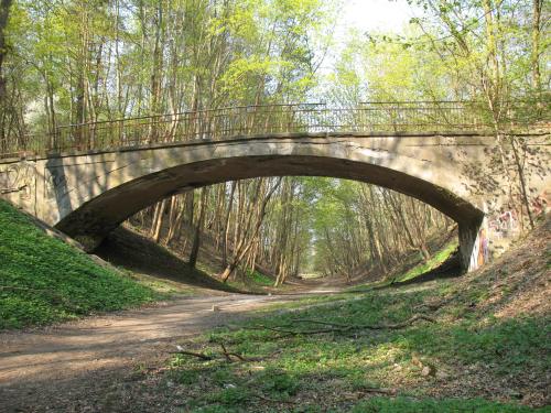
"Weiser Bridge" - colloquial name of bridge above old rail trail. Railway from Gdańsk Wrzeszcz to Stara Piła have been used since 1914 to 1945. In last days of war, Germans destroyed most of bridges on that track to paralyze traffic in the city.
After WWII track was demolished.
Nobody knows, if there any special functions of that bridge. I heard that could be road to forest restaurant or gravel-pit. Maybe it was just a big footbridge.
The cache:
Cache is at the coordinates (+/- 6m). For those without GPS device: use hint.
Please make sure that You hide it well!
 Dodatkowe informacje
Musisz być zalogowany, aby zobaczyć dodatkowe informacje.
 Obszary ochrony przyrody
| Prawdopodobnie skrzynka znajduje się na obszarze: | |
| Trójmiejski Park Krajobrazowy |

|
 Obrazki/zdjęcia

 Wpisy do logu:
28x
2x
9x
Wpisy do logu:
28x
2x
9x


