

 Please log in to see the coordinates.
 212x Found
  2x Not found
  7 notes
  11 watchers
  Rated as: Excellent
 110 x recommended


 Cache attributes


 Description
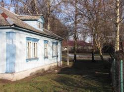
‘Friendship’ Estate is probably one of most pleasant places for a walk in the whole city. The atmosphere of this place is unique - the buildings look a bit like manors, and the area may bring associations to a holiday camp from communistic times in Poland. The district is full of green, it is idyllic and calm, differently than the surrounding districts with blocks of flats.
The district was founded in 1952 as a place to live for Soviet workers, who were employed by the construction of Palace of Culture. An unconfirmed information says that some of the houses were brought here from the disassembled former German prisoner camp (Stalag) I B “Hohenstein” near Olsztynek in northern Poland. Supposedly, some inhabitants found later German inscriptions on the buildings’ elements. Other version reports that it was not a prisoner camp, but a pre-war estate.
The aim was to create a self-sustainable estate, so that its inhabitants had no need to walk outside. The full social facilities were provided here - canteen, library, cinema. The workers were transported to the construction of Palace of Culture by buses. Simple workers lived it big, one-floored houses, and small one-family houses were constructed for engineers. A canteen was situated in a separate building, as well as the bathhouse, one for the whole estate. Nearly all buildings were made of wood, this is why they are sometimes called Finnish houses.
After the construction of Palace of Culture was finished and Soviet workers moved out, the estate was handed over to Warsaw’s high schools. The big houses became student dormitories, and university workers with families moved to former engineers’ houses. Most of the buildings held those functions until today. Only the function of former social building changed - today they have mainly commercial use.
In the initial point you will find here an object, which remembers the time of the estate's construction (in winter it may be covered with snow). You have to count M letters on it and note down this number as M.
It is also essential to get the digits from A to F, which are printed in the logbooks of stage caches (the traditional ones), which are located at the characteristic places of the estate:
Friendship Estate - Workers' Houses
Friendship Estate - Canteen
Friendship Estate - Engineers' Houses
Friendship Estate - Bathhouse
Friendship Estate - Playground
Friendship Estate - Workers' Club
Then, you can count the coordinates of the final cache, which are:
N 52° 14.x E 020° 55.y
where x and y are three-digit numbers, you have to count them as follows:
x = B*C*D + A*D*F + A*D*M + A*C*F + A*E*M
y = B*C*E + A*F*M + B*E*F + B*C*F + A*C*D
No other hints are available ! I wish you a nice walk and successes in searching and counting ! :)
 OpenChecker
 GeoKrety
 Geo-Pamiętnik
- Total distance: 11645 km
Geo-Pamiętnik
- Total distance: 11645 km
 Log entries:
212x
2x
7x
Log entries:
212x
2x
7x


