Największy na świecie niekomercyjny serwis geocachingowy
GeoŚcieżki - skupiające wiele keszy
Ponad 1000 GeoŚcieżek w Polsce!
Pełne statystyki, GPXy, wszystko za darmo!
Powiadomienia mailem o nowych keszach i logach
Centrum Obsługi Geokeszera wybierane przez Społeczność
100% funkcjonalności dostępne bezpłatnie
Przyjazne zasady publikacji keszy
You have to be logged-in in order to perform operations on this cache.
stats
Show cache statistics
GÓRNE.... - OP9RCW
czyli nahorne
Owner: norbinorek
This cache belongs to GeoPath!
Please log in to see the coordinates.
Altitude: m. ASL.
 Region: Slovakia (Slovak Republic) > Stredné Slovensko
Cache type: Traditional
Size: Small
Status: Ready for Search
Date hidden: 10-10-2023
Date created: 10-10-2023
Date published: 10-10-2023
Last modification: 10-10-2023
3x Found
0x Not found
0 notes
watchers 0 watchers
11 visitors
3 x rated
Rated as: Excellent
2 x recommended
This cache is recommended by: Chochlik., Hasioki
In order to view coordinates and
the map of caches
you must be logged in
Cache attributes

Go geocaching with children  One-minute cache  Take something to write  Nature  Access only by walk 

Please read the Opencaching attributes article.
Description PL

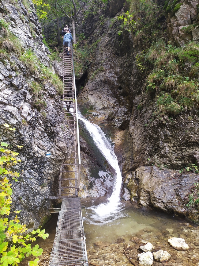
Z KOLIBY PODZIAR KIERUJ SIĘ NIEBIESKIM SZLAKIEM.

Przespacerowanie Górnych Dier zajmuje około 40 minut, a szlak wiedzie wzdłuż 9 wodospadów! 

Wąwóz bogaty w piękne wodospady, różnorodną roślinność, ciekawe formy skalne. Kilka kładek, drabinek i łańcuchów doprowadza do kolejnej krzyżówki  Pod Palenicou. Tu jest moment na podjęcie decyzji w sprawie dalszej wędrówki, bo będzie jeszcze trudniej?

Rules of reactivation Reaktywacja jest możliwa, o ile istnieje pewność, że skrzynka zaginęła
Read more about reactivation of geocaches here
Additional hints
You must be logged-in to see additional hints
Pictures
IMG_20231007_130314
IMG_20231007_131633
IMG_20231007_131850
w norce
Log entries: Found 3x Not found 0x Note 0x All entries