Największy na świecie niekomercyjny serwis geocachingowy
GeoŚcieżki - skupiające wiele keszy
Ponad 1000 GeoŚcieżek w Polsce!
Pełne statystyki, GPXy, wszystko za darmo!
Powiadomienia mailem o nowych keszach i logach
Centrum Obsługi Geokeszera wybierane przez Społeczność
100% funkcjonalności dostępne bezpłatnie
Przyjazne zasady publikacji keszy
Je moet ingelogd zijn om deze cache te loggen of te bewerken.
stats
Toon cache statistieken
Ostrów Tumski - OP8U2R
Ostrów Tumski
Eigenaar: mstachul
Log in om de coördinaten te kunnen zien.
Hoogte: 56 meter NAP
 Provincie: Polen > wielkopolskie
Cache soort: Multi Cache
Grootte: Micro
Status: Kan gezocht worden
Geplaatst op: 01-01-2018
Gemaakt op: 17-07-2018
Gepubliceerd op: 17-07-2018
Laatste verandering: 04-06-2021
52x Gevonden
0x Niet gevonden
6 Opmerkingen
watchers 0 Volgers
170 x Bekeken
32 x Gewaardeerd
Beoordeeld als: goed
Om de coördinaten en de kaart te zien
van de caches
moet men ingelogd zijn
Cache attributen

Go geocaching with children  Accessible for disabled  Bike  Take something to write  Monumental place  Access only by walk 

Lees ook het Opencaching attributen beschrijving artikel.
Beschrijving PL

 Ostrów Tumski w Poznaniu – jedyna pozostała z licznych niegdyś w Poznaniu wysp na Warcie. Otaczają ją dwa ramiona rzeki: szersze, zachodnie, które obecnie stanowi główny nurt Warty, oraz węższe, wschodnie, nazywane Cybiną, podobnie jak rzeczka, przepływająca przez Jezioro Maltańskie i do tego ramienia uchodząca, pełniąca też rolę wschodniego kanału ulgi. Z lądem Ostrów Tumski łączą mosty: Bolesława Chrobrego (z lewym brzegiem) i Mieszka I (z prawym brzegiem). Dnia 7 grudnia 2007 roku został otwarty most biskupa Jordana, który przywrócił historyczne połączenie wyspy ze Śródką. W 2014 roku, wraz z budową Interaktywnego Centrum Historii Ostrowa Tumskiego, powstała oszklona kładka nad Cybiną, na północ od mostu Biskupa Jordana. Zespół urbanistyczno-architektoniczny Ostrowa Tumskiego i Śródki od 6 października 1982 roku figuruje w rejestrze zabytków pod numerem A-239. W 2008 uznany został przez prezydenta RP, w ramach historycznego zespołu miasta Poznania, jako pomnik historii.


 Ostrów Tumski (meaning "Cathedral Island"; German Dom Insel) is an island between two branches of the river Warta in the city of Poznań in western Poland. Poznań Cathedral and other ecclesiastical buildings occupy the central part of the island. Ostrów Tumski is part of the city's former Nowe Miasto ("New Town") district, although it is actually the oldest part of the city, where the rulers of the early Polish state in the 10th century had one of their palaces.The site is listed as one of Poland's official national Historic Monuments (Pomnik historii), as designated November 28, 2008, along with other portions of the city's historic core. Its listing is maintained by the National Heritage Board of Poland.

Bazylika


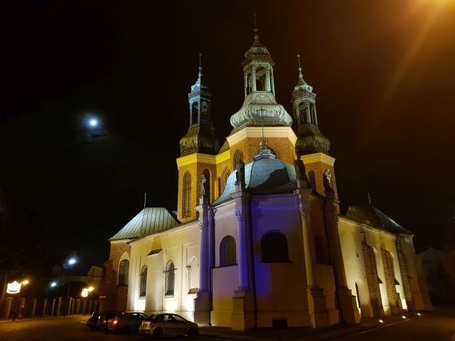
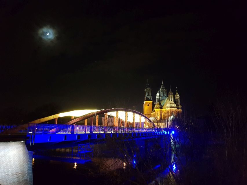
Najważniejszymi zabytkami i innymi obiektami na Ostrowie Tumskim są:

  • Bazylika Archikatedralna świętych Apostołów Piotra i Pawła, zwana popularnie katedrą
  • Pałac arcybiskupi
  • Kościół Najświętszej Marii Panny
  • Psałteria z XVIw.
  • Akademia Lubrańskiego
  • Wyższe Seminarium Duchowne Towarzystwa Chrystusowego dla Polonii Zagranicznej
  • Arcybiskupie Seminarium Duchowne
  • Rezerwat Archeologiczny Genius Loci
 

Buildings of interest in the historic central part of Ostrów Tumski include:

  • Poznań Cathedral
  • The archbishop's palace
  • The Church of the Most Holy Virgin Mary
  • The Psalmodists' House
  • The Lubrański Academy
  • The seminary buildings
  • Archaeological Reserve Genius loci

muzeum


więcej: Ostrów Tumski w Poznaniu


more: Ostrów Tumski, Poznań

most biskupa Jordana

---


Lokalizację pojemnika finałowego zdobędziesz gdy do wzoru

N 52° 24.[765-B] E 016° 56.[854+A]

podstawisz: 

A=liczba liter w słowach znajdujących się na reperze w lokalizacji startowej.

B=liczba liter w dwóch łacińskich słowach z nazwy Rezerwatu znajdującego się na kordach etapu 2.


Final:

N 52° 24.[765-B] E 016° 56.[854+A]

A=count of letters in the text on the benchmark in the starting location.

B=count of letters in two Latin words in the name of the Reserve located on the initial cords.

OpenChecker
Deze cache eigenaar geeft je de kans om de eindcoördinaten te controleren. Doe dit voordat je gaat zoeken!
Statistieken: Pogingen: 20 keer, Hits: 7 keer.
Extra waypoints
WP nummer Symbool Soort Coördinaten Beschrijving
1 Virtueel punt --- etap 2
2 Eindlocatie --- finał
Extra hints
Je moet ingelogd zijn om de hints te zien
Logs: Gevonden 52x Niet gevonden 0x Opmerking 6x Afbeelding 2x Alle logs Galerij