

 Log in om de coördinaten te kunnen zien.
 21x Gevonden
  0x Niet gevonden
  1 Opmerkingen
  5 Volgers
  Beoordeeld als: uitstekend
 1 x Aanbevolen


 Cache attributen


 Beschrijving
Another practical problem to solve. This time numbers won’t be exactly real, they will only let us to realise some problem and to count the coordinates of the cache.
In the second half of year 2016 we had had so many rainy days, that sometimes the water just poured down from the sky. In such moments we probably think, what happens later to all that water. The answer seems to be simple – it sinks into the ground. OK, but what if it goes to a surface, which is not able to absorb anything – such as an asphalt street, a pavement, a building or a playground with tartan surface. We could think that in such situation it is also simple – it will flow to a neighbouring ground (for example grass) and sink into it or run down to the sewage system. Sure, but both of those ‘collectors’ do not have an unlimited capacity. The more surface in the city we cover with buildings, streets and so on, the less such-called biologically active areas are left (forests, parks, grass, lakes) and the more rain water from the neighbouring areas they have to collect. Another way is to develop sewage system, but always it will have a limited capacity, what is important especially when a really heavy rain happens.
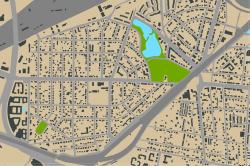
How does it look like in practise ? In Nowe Włochy district, counting briefly, we can estimate that about 40-50 % of the area are impermeable surfaces (buildings, streets, pavements etc.) and the rest (50-60 %) are biologically active areas. That is anyway much better than in the centre of Warsaw.
What do we have to count to find the cache ?
1. Our terrain is the western part of Nowe Włochy: the area limited by streets: Promienista, Łuki Małe, Pianistów, Rybnicka, Przepiórki, Świerszcza, Cykady. The following scheme illustrates it.
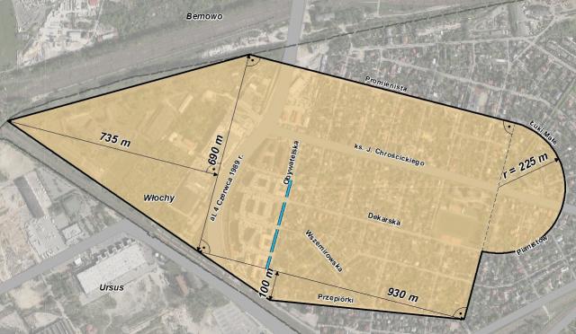
We count its area with the precision of 100 m2 (we round-off to full 100 m2). The sum of the digits of the number we will get should be 7.
2. Now let’s imagine that a heavy rain pours down to all that terrain – 30 mm of water.
3. We assume that 60% of the terrain are biologically active areas, so the water can sink down directly to it.
4. And from the rest 40% of area – we assume that 80% of the water will flow to the neighbouring grass, gardens etc. and the rest 20% have to flow to the sewage system. We count the capacity of that water with accuracy of 1 m3.
5. The water from the rain water sewage system will flow into the collector, which is the ditch along Obywatelska street. This ditch consist of 4 courses (60, 80, 80 and 45 metres long) and its section is a isosceles triangle of 4-metre base and 3,5-metre height. We assume that there was no water in the ditch when the rain began.
6. How much capacity of the rain water the pumping station located at the end of the ditch have to pump out from the ditch, before all water flows into it, so that the ditch would not overfill ? In other words, we count the capacity of rain water which will flow into the ditch and then subtract the capacity of the ditch. The number we will get (in m3) is X, then we can count the coordinates of the cache.
N 52 12.X-193 E 20 53.X+84
 OpenChecker
 Afbeeldingen
 Logs:
21x
0x
1x
Logs:
21x
0x
1x


