

 Please log in to see the coordinates.

 Rated as: n/a


 Cache attributes


 Description
PL
Description
PL
PL: Nieistniejący już cmentarz sudecki w pobliżu granicy państwa
CS: Zaniklý sudetský hřbitov nedaleko státní hranice
EN: Destroyed Sudeten cemetery near the state border
Dawny cmentarz wsi Hermsdorf
Heřmanice (po niemiecku Hermsdorf) to mała wieś, część miasta Králíky, w powiecie Ústí nad Orlicí. Znajduje się około pięciu kilometrów na północ od Králíku. Heřmanice znajdują się na obszarze katastralnym Heřmanice u Králík o powierzchni 5,56 km². Pierwsza pisemna wzmianka o wsi pochodzi z 1577 roku. Do wysiedleń ludności po II. przed II wojną światową większość mieszkańców wsi stanowiła narodowość niemiecka. Przez większą część swojej historii wieś nazywała się po niemiecku Hermsdorf.
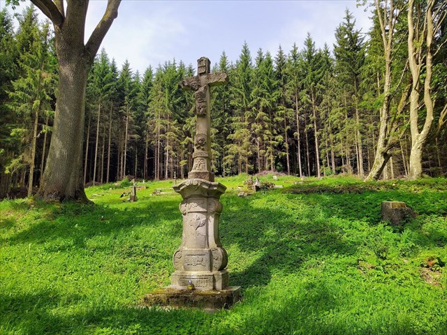
Zaniklý hřbitov obce Hermsdorf
Heřmanice (německy Hermsdorf) je malá vesnice, část města Králíky v okrese Ústí nad Orlicí. Nachází se asi pět kilometrů severně od Králík. Heřmanice leží v katastrálním území Heřmanice u Králík o rozloze 5,56 km². První písemná zmínka o vesnici pochází z roku 1577. Do odsunu obyvatelstva po II. světové válce byla většina obyvatel obce německé národnosti. Obec se po větší část své historie nazývala německy Hermsdorf.
Destroyed cemetery of the village of Hermsdorf
Heřmanice (in German Hermsdorf) is a small village, part of the town of Králíky, in the district of Ústí nad Orlicí. It is located about five kilometres north of Králík. Heřmanice is located in the cadastral area of Heřmanice u Králík with an area of 5.56 km². The first written mention of the village dates back to 1577. Until the expulsions after World War II, the majority of the village's inhabitants were German. For most of its history, the village was called by its German name Hermsdorf.
[Last listing update: 09.12.2024; unsaved]
Additional Hidden Waypoints
P1AV41N - Parking
N 50° 07.616 E 016° 45.014
Nenapadne parkovani u kontejneru na trideny odpad, fakt sve auto nenechavej chatarum v ceste.
V1AV41N - Water
N 50° 07.877 E 016° 45.233
Fresh water spring. Silny pramen cerstve vody.
 Additional hints
 Log entries:
 2x
2x
 0x
0x
 0x
0x


