Największy na świecie niekomercyjny serwis geocachingowy
GeoŚcieżki - skupiające wiele keszy
Ponad 1000 GeoŚcieżek w Polsce!
Pełne statystyki, GPXy, wszystko za darmo!
Powiadomienia mailem o nowych keszach i logach
Centrum Obsługi Geokeszera wybierane przez Społeczność
100% funkcjonalności dostępne bezpłatnie
Przyjazne zasady publikacji keszy
You have to be logged-in in order to perform operations on this cache.
stats
Show cache statistics
Szlak Rambla de Castro - OP9XXQ
Owner: Hawajek
Please log in to see the coordinates.
Altitude: m. ASL.
 Region: Spain > Canarias
Cache type: Traditional
Size: Micro
Status: Ready for Search
Time required: 1:00 h    Distance to travel: 3.00 km
Date hidden: 12-08-2024
Date created: 11-09-2024
Date published: 11-09-2024
Last modification: 11-09-2024
1x Found
0x Not found
0 notes
watchers 0 watchers
11 visitors
1 x rated
Rated as: n/a
In order to view coordinates and
the map of caches
you must be logged in
Cache attributes

One-minute cache  Take something to write  Nature  Monumental place 

Please read the Opencaching attributes article.
Description PL

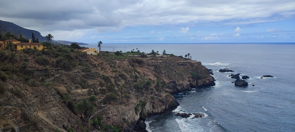
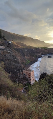
Kesz znajduje się przy pieszym szlaku Rambla de Castro, niedaleko San Vincente. Szlak swój początek ma przy punkcie widokowym Mirador El Burgado-Playa Los Roques, a kończy się przy punkcie widokowym Mirador San Pedro. Szlak ma długość cztery kilometry, przebiega wzdłuż klifu. Można z niego zejść do dwóch kameralnych plaż z czarnym piaskiem. W pobliżu plaża Socorro, tak zwana plaża "serferów".


Żeby odnaleźć kesza nie trzeba kopać. Na zakręcie szlaku trzeba z niego zejść. Uważaj zejście pokryte jest sypkim żwirem. Szukaj fal.

Rules of reactivation Reaktywacja jest możliwa, o ile istnieje pewność, że skrzynka zaginęła
Read more about reactivation of geocaches here
Pictures
znak
szlak
budynek
Fortin de San Fernando
Log entries: Found 1x Not found 0x Note 0x Picture 3x All entries Gallery