Największy na świecie niekomercyjny serwis geocachingowy
GeoŚcieżki - skupiające wiele keszy
Ponad 1000 GeoŚcieżek w Polsce!
Pełne statystyki, GPXy, wszystko za darmo!
Powiadomienia mailem o nowych keszach i logach
Centrum Obsługi Geokeszera wybierane przez Społeczność
100% funkcjonalności dostępne bezpłatnie
Przyjazne zasady publikacji keszy
You have to be logged-in in order to perform operations on this cache.
stats
Show cache statistics
Most na rudnym szlaku - OP9GA6
Stąporków
Owner: dzejbi
Please log in to see the coordinates.
Altitude: 255 m. ASL.
 Region: Poland > świętokrzyskie
Cache type: Traditional
Size: Micro
Status: Ready for Search
Date hidden: 04-12-2021
Date created: 04-12-2021
Date published: 04-12-2021
Last modification: 04-12-2021
13x Found
0x Not found
1 notes
watchers 0 watchers
71 visitors
10 x rated
Rated as: Good
In order to view coordinates and
the map of caches
you must be logged in
Cache attributes

Go geocaching with children  One-minute cache  Nature 

Please read the Opencaching attributes article.
Description PL

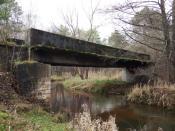
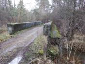
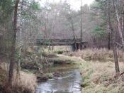
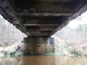
 Most nad Czarną Konecką na byłej bocznicy kolejki dowożącej rudę żelaza z kopalni "Stara Góra", "Czarny Las", "Piekło" i innych, do punktu przeładunkowego w Stąporkowie, skąd później do hut w Starachowicach i Ostrowcu. Most o dużej nośności w środku lasu, industrialny ślad linii kolejowej, obsługujących byłe kopalnie Zagłębia Staropolskiego.

Rules of reactivation Reaktywacja jest możliwa tylko po bezpośrednim kontakcie z autorem/właścicielem skrzynki
Read more about reactivation of geocaches here
Additional hints
You must be logged-in to see additional hints
Pictures
most
most
most
most
spoiler
Log entries: Found 13x Not found 0x Note 1x Picture 1x All entries Gallery