

 Zaloguj się, by zobaczyć współrzędne.
 13x znaleziona
  0x nieznaleziona
  0 komentarze
  1 obserwatorów
  Oceniona jako: znakomita
 1 x rekomendowana


aby zobaczyć współrzędne oraz
mapę lokalizacji skrzynki
 Atrybuty skrzynki


 Opis
PL
Opis
PL
English version below.
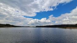
W skład Gór Świętokrzyskich wchodzi kilkanaście równoległych pasm, ciągnących się z zachodu na wschód.
Najwyższym z nich są Łysogóry. Z tego miejsca do najwyższej ich kulminacji czyli do Łysicy (614 m n.p.m.) mamy w linii prostej 11 kilometrów a do Łysej Góra (Łysiec, Święty Krzyż - 594 m n.p.m.) 21 km. gdyby więc nie było drzew w pobliżu byłaby szansa dostrzec stąd te wzniesienia.
Z regionem świętokrzyskim związane są liczne legendy. Bodaj najbardziej znane to te o czarownicach, które na swoje sabaty miały niegdyś zlatywać się na Łysą Górę.
Jeśli chcesz poznać te legendę, kliknij w poniższy link:
https://rugala.pl/blog/2011/11/legendy-o-gorach-swietokrzyskich/#o-sabatach
O samej skrzynce:
- pojemnik mikro, ale z maskowaniem wielkość mała
- maskowanie regionalne
- w razie potrzeby użyj spojlera.
Dobrej zabawy!
===============
The Świętokrzyskie Mountains consist of several parallel ranges, stretching from west to east.

The highest of them are Łysogóry. From this place to their highest peak -
Łysica (614 m above sea level) we have 11 kilometers in a straight line and
to Łysa Góra (Łysiec, Święty Krzyż - 594 m above sea level) 21 km.
So if there were no trees nearby there would be a chance to see these hills from here.

There are many legends associated with the Świętokrzyskie region
 Perhaps the most famous are those about witches who used to fly to Łysa Góra for their sabbaths.

If you want to learn about this legend, click on the link below:
 https://rugala.pl/blog/2011/11/legendy-o-gorach-swietokrzyskich/#o-sabatach

About the box itself:

- micro container, but small size with camouflage

- regional camouflage

- use a spoiler if necessary.

Have fun!  Dodatkowe informacje
 Wpisy do logu:
13x
0x
0x
Wpisy do logu:
13x
0x
0x


