
 First you need to find {CFrequirment} Caches to create a new GeoPath
|
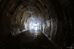
MRU - podziemia | ||
|
|
|||
| GeoPath details | |||
| Mentor (?) |
r00t7 | ||
| Completed | 47 times | ||
| Scoring | 212.78 Points | ||
| Number of caches | 21 (0 / 0 / 0) | ||
| % cache finds required to complete GeoPath | 70% ( Geocaches) | ||
| GeoPath type | Thematic | ||
| Publication date | 20-09-2018 | ||
| Owners | r00t7 | ||
| GeoPath's description | |||

UWAGA, ZWIEDZACIE NA WŁASNĄ ODPOWIEDZIALNOŚĆ. UPRASZA SIĘ O NIE POZOSTAWIANIE PO SOBIE NICZEGO POZA ODCISKAMI STÓP !!!
Międzyrzecki Rejon Umocniony
Umocniony Łuk Odry i Warty
Ostwall albo Festungsfront im Oder-Warthe Bogen (FFOWB lub OWB))
Potężny system poniemieckich fortyfikacji, powstały w latach 30. XX w. na pograniczu niemiecko – polskim. Położony jest w łuku Odry i Warty oraz rozciąga na odcinku ok. 100 km. Najważniejszym elementem fortyfikacji jest system podziemnych tuneli wybudowanych w okolicach Międzyrzecza, o łącznej długości przekraczającej 30 km. Podziemia stanowią element Muzeum Fortyfikacji i Nietoperzy w Pniewie, przy którym zorganizowana jest całoroczna trasa turystyczna.
źródło: klubpodroznikow.com
| Caches in this GeoPath MRU - podziemia |

|


Statistics for this GeoPath MRU - podziemia
Opinions and comments


