Największy na świecie niekomercyjny serwis geocachingowy
GeoŚcieżki - skupiające wiele keszy
Ponad 1000 GeoŚcieżek w Polsce!
Pełne statystyki, GPXy, wszystko za darmo!
Powiadomienia mailem o nowych keszach i logach
Centrum Obsługi Geokeszera wybierane przez Społeczność
100% funkcjonalności dostępne bezpłatnie
Przyjazne zasady publikacji keszy
geocache GeoPaths
GeoPath name
GeoPath type What is this?HelpHelpSpecifies the type of GeoPath. If the majority of caches are arranged in a line, or form a design on the map, set Geo-sketch . If the majority of caches highlight a tourist attraction (e.g. a famous building, museum, etc.) set Touristic . If the majority of caches show off a natural feature (e.g. a mountain peak, viewpoint, etc.) set Nature . If the caches have a common theme (e.g. cathedrals, famous authors, etc.) set Thematic . If you think your GeoPath should be in another category which is not listed, contact the OC Team cog (at) opencaching.pl
% cache finds required to complete GeoPath
What is this?HelpHelpAfter logging a percentage of the caches, the user may log the GeoPath as completed
GeoPath Description

Start a new GeoPath
Waypoint Cache name belongs to GeoPath  
(No caches to display)
GeoPaths
Number of displayed GeoPaths: {displayedPowerTrailsCount} Display options
Name Type {statusOrPoints} Publication date Number of caches Completed


Z MOSTÓW NA WIELKI POŁOM

GeoPath details
Mentor (?)HelpMentorThe mentor is the person who created the GeoPath. Mario&Monia
Visibility
Completed 4 times
Scoring 81.86 Points
Number of caches 11 (0 / 0 / 0)
% cache finds required to complete GeoPath 100% ( Geocaches)
GeoPath type Nature
Publication date 27-02-2024
Owners Mario&Monia, Chochlik.
GeoPath's description

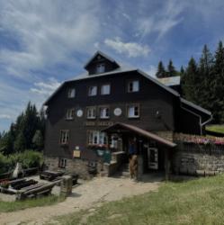
Witajcie . Wraz z Chochlikiem zapraszamy Was serdecznie w piękne rejony Beskidu Śląsko-Morawskiego na najwyższy szczyt
Masywu Wielkiego Połomu – Wielki Połom 1067m n.p.m. położony na granicy pomiędzy Czechami i Słowacją.
Po obu stronach zachowane fragmenty pierwotnego lasu bukowo-jodłowego chronione są w rezerwatach przyrody. Ze szczytu roztacza się panorama m.in. na Małą Fatrę.

Trasa:

Szlak czerwony -Mosty u Jablunkova (parking przy stacji kol.) – Kyčera – ch. Skalka – Kostelky/ch. Severka – Kamenna chata – Velký Polom – Kamenna chata – Rozhledna Tetřev (wieża widokowa) – Kostelky-zmiana na szlak niebieski -Beskyd -Motyćanka-Śance- Mosty u Jablunkova (chodnikiem koło jezdni)

Trasa na około 6-7 godzin z obiadem w jednym schronisku i deserem w drugim , wejściem na wieże Tetrev . Dystans ok 17 - 19 km, suma podejść nie przekracza 600m, a najwyższy punkt to 1067m n.p.m.

Caches in this GeoPath Z MOSTÓW NA WIELKI POŁOM

include following caches in gpx file:


inactive
ignored
placed by you
watched
founded
Logs count in gpx file*: 5

*) - for each cache. Available only for "GPX" files OK
information
Statistics for this GeoPath Z MOSTÓW NA WIELKI POŁOM
Your progress on this GeoPath


0% (You found 0 from 11 Caches in the Geopath)

Show more statistics

Opinions and comments

Log your visit