
 First you need to find {CFrequirment} Caches to create a new GeoPath
|
Dalekie Obserwacje | ||
|
|
|||
| GeoPath details | |||
| Mentor (?) |
kopernik18 | ||
| Completed | 2 times | ||
| Scoring | 119.91 Points | ||
| Number of caches | 18 (0 / 0 / 0) | ||
| % cache finds required to complete GeoPath | 90% ( Geocaches) | ||
| GeoPath type | Touristic | ||
| Publication date | 03-10-2019 | ||
| Owners | kopernik18 | ||
| GeoPath's description | |||
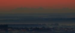
Dzięki tej geościeżce można odwiedzić punkty widokowe w Kielcach i okolicach. W szczególności wybrałem te które nadają się do obserwacji... Tatr. To odległość około 200 km z okolic miasta Kielce. Na pewno wielu z Was to zaskoczy, że to w ogóle możliwe ale zapraszam na stronę http://www.dalekieobserwacje.eu Tam jest wiele tego typu podobnych obserwacji. Symulacje widoczności można robić za pomocą strony https://www.udeuschle.de/panoramas/makepanoramas.htm
Na tego typu obserwacje najlepiej wybrać się o wschodzie lub zachodzie słońca. Musi być idealna przejrzystość powietrza od Kielc aż do Tatr. Najlepiej po przejściu frontu atmosferycznego, silnej wichury albo gdy zacznie wiać halny w Tatrach.
Dzięki poniższej kamerze online z okolic Tarnowa można sprawdzić czy widać Tatry z odległości 100 km. Jeżeli tam widoczność jest słaba to stąd raczej ich nie zobaczymy.
https://www.ipcamlive.com/brzanka
Warunkiem zaliczenia każdego kesza jest dodatkowo dołączenie zdjęcia w kierunku południowym z podanych współrzędnych
Powodzenia w ustrzeleniu Tatr!
| Caches in this GeoPath Dalekie Obserwacje |

|


