Największy na świecie niekomercyjny serwis geocachingowy
GeoŚcieżki - skupiające wiele keszy
Ponad 1000 GeoŚcieżek w Polsce!
Pełne statystyki, GPXy, wszystko za darmo!
Powiadomienia mailem o nowych keszach i logach
Centrum Obsługi Geokeszera wybierane przez Społeczność
100% funkcjonalności dostępne bezpłatnie
Przyjazne zasady publikacji keszy
geocache GeoPaths
GeoPath name
GeoPath type What is this?HelpHelpSpecifies the type of GeoPath. If the majority of caches are arranged in a line, or form a design on the map, set Geo-sketch . If the majority of caches highlight a tourist attraction (e.g. a famous building, museum, etc.) set Touristic . If the majority of caches show off a natural feature (e.g. a mountain peak, viewpoint, etc.) set Nature . If the caches have a common theme (e.g. cathedrals, famous authors, etc.) set Thematic . If you think your GeoPath should be in another category which is not listed, contact the OC Team cog (at) opencaching.pl
% cache finds required to complete GeoPath
What is this?HelpHelpAfter logging a percentage of the caches, the user may log the GeoPath as completed
GeoPath Description

Start a new GeoPath
Waypoint Cache name belongs to GeoPath  
(No caches to display)
GeoPaths
Number of displayed GeoPaths: {displayedPowerTrailsCount} Display options
Name Type {statusOrPoints} Publication date Number of caches Completed


Między Kościółkiem a Jeleniem

GeoPath details
Mentor (?)HelpMentorThe mentor is the person who created the GeoPath. NivilS
Visibility
Completed 0 times
Scoring 198.03 Points
Number of caches 30 (0 / 0 / 0)
% cache finds required to complete GeoPath 100% ( Geocaches)
GeoPath type Touristic
Publication date 27-09-2025
Owners NivilS
GeoPath's description

Ścieżka spacerowa " Między Kościółkiem a Jeleniem"

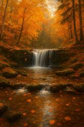
Ścieżka "Miedzy Kościółkiem a Jeleniem" to szlak prowadzący od Szumów nad Tanwią przez Wzgórze Kościółek do wodospadu Jeleń i dalej z powrotem do Szumów nad Tanwią. Sam szlak ma długoś około 6 km a wraz Szumami będzie tego do przedreptania coś koło 8-9 km. Czas przejścia  pętli to około 2h. Ale jak chcecie keszować i fotografować to  trzeba będzie przeznaczyć około 3- 3,5 h. A jeśli chcecie robić też ścieżkę nad Tanwią to trzeba będzie jeszcze z godzinkę lub 1,5 dodać. Większość trasy pokonujemy niebieskim szlakiem aż do wodospadu Jeleń. Przy wodospadzie odbijamy na żółty szlak który doprowadzi nasz powrotem nad Tanew.

Szlak przyjemny i miejscami widokowy. Większość trasy da się pokonać rowerem ale w kilku miejscach trzeba będzie się otargać.. Mam nadzieje że opiszecie swoje wrażenia z targania roweru między keszem 17 i 18  ;).

Z zasięgiem różnie, więc zgrajcie sobie spojlery, mogą wiele pomóc.

Powodzenia

Caches in this GeoPath Między Kościółkiem a Jeleniem

include following caches in gpx file:


inactive
ignored
placed by you
watched
founded
Logs count in gpx file*: 5

*) - for each cache. Available only for "GPX" files OK
information
Statistics for this GeoPath Między Kościółkiem a Jeleniem
Your progress on this GeoPath


0% (You found 0 from 30 Caches in the Geopath)

Show more statistics

Opinions and comments

Log your visit