Największy na świecie niekomercyjny serwis geocachingowy
GeoŚcieżki - skupiające wiele keszy
Ponad 1000 GeoŚcieżek w Polsce!
Pełne statystyki, GPXy, wszystko za darmo!
Powiadomienia mailem o nowych keszach i logach
Centrum Obsługi Geokeszera wybierane przez Społeczność
100% funkcjonalności dostępne bezpłatnie
Przyjazne zasady publikacji keszy
geocache GeoPaths
GeoPath name
GeoPath type What is this?HelpHelpSpecifies the type of GeoPath. If the majority of caches are arranged in a line, or form a design on the map, set Geo-sketch . If the majority of caches highlight a tourist attraction (e.g. a famous building, museum, etc.) set Touristic . If the majority of caches show off a natural feature (e.g. a mountain peak, viewpoint, etc.) set Nature . If the caches have a common theme (e.g. cathedrals, famous authors, etc.) set Thematic . If you think your GeoPath should be in another category which is not listed, contact the OC Team cog (at) opencaching.pl
% cache finds required to complete GeoPath
What is this?HelpHelpAfter logging a percentage of the caches, the user may log the GeoPath as completed
GeoPath Description

Start a new GeoPath
Waypoint Cache name belongs to GeoPath  
(No caches to display)
GeoPaths
Number of displayed GeoPaths: {displayedPowerTrailsCount} Display options
Name Type {statusOrPoints} Publication date Number of caches Completed


BlueVelo Lubczyna-Stepnica

GeoPath details
Mentor (?)HelpMentorThe mentor is the person who created the GeoPath. NGTgoleniow
Visibility
Completed 0 times
Scoring 116.65 Points
Number of caches 15 (0 / 0 / 0)
% cache finds required to complete GeoPath 90% ( Geocaches)
GeoPath type Touristic
Publication date 24-09-2025
Owners NGTgoleniow
GeoPath's description

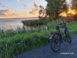
Około 30 km fragment rowerowej trasy BlueVelo.

Między Lubczyną, a Modrzewiem jedzie się szutrówką po wałach przeciwpowodziowych, najpierw przy brzegu Jeziora Dąbie, a potem przy brzegu rzeki Iny. W okolicy Rybaków Lubczyńskich można w wodzie wypatrzyć wrak betonowca. Patrzymy na północny zachód, w kierunku Polic. Rowerzyści z terenowym zacięcięm mogą opuścić BV i podjechać bliżej betonowca. Jest tam miejsce biwakowo-ogniskowo-plażowe. Są też stawy nawigacyjne i pozostałości po wsi Inoujście.

Między Modrzewiem, a Stepnicą pojedziemy trochę płytami betonowymi, trochę asfaltowym paskiem obok drogi i trochę lasem.

Możliwość zrobienia zakupów jest w Lubczynie, Modrzewiu, Krępsku i Stepnicy. Przy wjeździe do Stepnicy jest specjalna wiata rowerowa.

Większość skrzynek jest łatwa i szybka do znalezienia, by rowerowi towarzysze nie przewracali oczami :-)

Caches in this GeoPath BlueVelo Lubczyna-Stepnica

include following caches in gpx file:


inactive
ignored
placed by you
watched
founded
Logs count in gpx file*: 5

*) - for each cache. Available only for "GPX" files OK
information
Statistics for this GeoPath BlueVelo Lubczyna-Stepnica
Your progress on this GeoPath


0% (You found 0 from 15 Caches in the Geopath)

Show more statistics

Opinions and comments

Log your visit