Największy na świecie niekomercyjny serwis geocachingowy
GeoŚcieżki - skupiające wiele keszy
Ponad 1000 GeoŚcieżek w Polsce!
Pełne statystyki, GPXy, wszystko za darmo!
Powiadomienia mailem o nowych keszach i logach
Centrum Obsługi Geokeszera wybierane przez Społeczność
100% funkcjonalności dostępne bezpłatnie
Przyjazne zasady publikacji keszy
geocache GeoPaths
GeoPath name
GeoPath type What is this?HelpHelpSpecifies the type of GeoPath. If the majority of caches are arranged in a line, or form a design on the map, set Geo-sketch . If the majority of caches highlight a tourist attraction (e.g. a famous building, museum, etc.) set Touristic . If the majority of caches show off a natural feature (e.g. a mountain peak, viewpoint, etc.) set Nature . If the caches have a common theme (e.g. cathedrals, famous authors, etc.) set Thematic . If you think your GeoPath should be in another category which is not listed, contact the OC Team cog (at) opencaching.pl
% cache finds required to complete GeoPath
What is this?HelpHelpAfter logging a percentage of the caches, the user may log the GeoPath as completed
GeoPath Description

Start a new GeoPath
Waypoint Cache name belongs to GeoPath  
(No caches to display)
GeoPaths
Number of displayed GeoPaths: {displayedPowerTrailsCount} Display options
Name Type {statusOrPoints} Publication date Number of caches Completed


Spacer nad Bystrzycą

GeoPath details
Mentor (?)HelpMentorThe mentor is the person who created the GeoPath. antekw31
Visibility
Completed 0 times
Scoring 116.7 Points
Number of caches 16 (0 / 0 / 0)
% cache finds required to complete GeoPath 92% ( Geocaches)
GeoPath type Touristic
Publication date 23-04-2025
Owners antekw31
GeoPath's description

Spacer nad Bystrzycą


Bystrzyca – największy lewobrzeżny dopływ Wieprza, jedna z rzek Wyżyny Lubelskiej. Swoje źródła ma w Sulowie (na wysokości 275 m n.p.m.). Przepływa przez Lublin. Całkowita długość rzeki wynosi 86,91 km, a powierzchnia jej dorzecza 1318,37 km². Poniżej miejscowości Spiczyn (na wysokości 152 m n.p.m.) uchodzi do Wieprza.

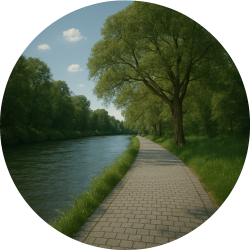
Zapraszam was na spacer nad bystrzycą. Długość ścieżki to lekko ponad 10 km. Można na niej podziwiać te miejsca Lublina bardziej cywilizowane oraz te gdzie można wyciszyć się od zgiełku dużego miasta.

Najbardziej polecam zdobywać kesze rowerem, ale również można pieszo. Nie polecam samochodem, bo do większości nie da się bezpośrednio dojechać.


Do wyciągnięcie niektórych logboków może przydać się pęseta.

Caches in this GeoPath Spacer nad Bystrzycą

include following caches in gpx file:


inactive
ignored
placed by you
watched
founded
Logs count in gpx file*: 5

*) - for each cache. Available only for "GPX" files OK
information
Statistics for this GeoPath Spacer nad Bystrzycą
Your progress on this GeoPath


0% (You found 0 from 16 Caches in the Geopath)

Show more statistics

Opinions and comments

Log your visit