Największy na świecie niekomercyjny serwis geocachingowy
GeoŚcieżki - skupiające wiele keszy
Ponad 1000 GeoŚcieżek w Polsce!
Pełne statystyki, GPXy, wszystko za darmo!
Powiadomienia mailem o nowych keszach i logach
Centrum Obsługi Geokeszera wybierane przez Społeczność
100% funkcjonalności dostępne bezpłatnie
Przyjazne zasady publikacji keszy
geocache GeoPaths
GeoPath name
GeoPath type What is this?HelpHelpSpecifies the type of GeoPath. If the majority of caches are arranged in a line, or form a design on the map, set Geo-sketch . If the majority of caches highlight a tourist attraction (e.g. a famous building, museum, etc.) set Touristic . If the majority of caches show off a natural feature (e.g. a mountain peak, viewpoint, etc.) set Nature . If the caches have a common theme (e.g. cathedrals, famous authors, etc.) set Thematic . If you think your GeoPath should be in another category which is not listed, contact the OC Team cog (at) opencaching.pl
% cache finds required to complete GeoPath
What is this?HelpHelpAfter logging a percentage of the caches, the user may log the GeoPath as completed
GeoPath Description

Start a new GeoPath
Waypoint Cache name belongs to GeoPath  
(No caches to display)
GeoPaths
Number of displayed GeoPaths: {displayedPowerTrailsCount} Display options
Name Type {statusOrPoints} Publication date Number of caches Completed


SZLAK FORTYFIKACJI SZCZYCIEŃSKIEJ POZYCJI LEŚNEJ 

GeoPath details
Mentor (?)HelpMentorThe mentor is the person who created the GeoPath. Victor+
Visibility
Completed 3 times
Scoring 42 Points
Number of caches 6 (0 / 0 / 0)
% cache finds required to complete GeoPath 80% ( Geocaches)
GeoPath type Thematic
Publication date 30-12-2024
Owners Victor+
GeoPath's description

SZLAK FORTYFIKACJI SZCZYCIEŃSKIEJ POZYCJI LEŚNEJ 


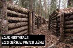
Szlak pieszy liczy 8 punktów, wśród nich idealnie zachowane obiekty z okresu I i II Wojny Światowej, przy których ustawione zostały tablice informacyjne. Przejście szlaku wiąże się z pokonaniem pętli o długości około 5 km, w sam raz za 2-godzinny spacer w okolicznościach mazurskiej przyrody. Przejażdżka rowerowa również nie będzie stanowiła problemu, teren dosyć łaskawy. Szlak jest bardzo dobrze oznaczony, nie sposób zboczyć ze ścieżki ani przeoczyć tablic informacyjnych. Zatem możecie oddać się przyrodzie, a garminy wyciągać jedynie przy bunkrach co by nie gapić się cały czas w ekran. Samochód polecam zaparkować na leśnym parkingu określonym waypointem. Skrzynki wielkości mikro/małej ukryte poza obiektami w odległości maksymalnie 20 metrów. Pojemniki zawierają jedynie logbook, koniecznie weźcie coś do pisania. 

Zdolności obronne okolicznych terenów uwarunkowane były poprzez naturalne przeszkody w postaci ukształtowania terenu oraz obfitość jezior. W ten sposób kształtowały się naturalne linie obrony. Wróg był zdolny przedostać się jedynie poprzez przesmyki miedzy jeziorami, stąd też Szczecińska Pozycja Leśna powstała miedzy jeziorami Zyzdrój Mały i Zdróżno.

Caches in this GeoPath SZLAK FORTYFIKACJI SZCZYCIEŃSKIEJ POZYCJI LEŚNEJ 

include following caches in gpx file:


inactive
ignored
placed by you
watched
founded
Logs count in gpx file*: 5

*) - for each cache. Available only for "GPX" files OK
information
Statistics for this GeoPath SZLAK FORTYFIKACJI SZCZYCIEŃSKIEJ POZYCJI LEŚNEJ 
Your progress on this GeoPath


0% (You found 0 from 6 Caches in the Geopath)

Show more statistics

Opinions and comments

Log your visit