Największy na świecie niekomercyjny serwis geocachingowy
GeoŚcieżki - skupiające wiele keszy
Ponad 1000 GeoŚcieżek w Polsce!
Pełne statystyki, GPXy, wszystko za darmo!
Powiadomienia mailem o nowych keszach i logach
Centrum Obsługi Geokeszera wybierane przez Społeczność
100% funkcjonalności dostępne bezpłatnie
Przyjazne zasady publikacji keszy
geocache GeoPaths
GeoPath name
GeoPath type What is this?HelpHelpSpecifies the type of GeoPath. If the majority of caches are arranged in a line, or form a design on the map, set Geo-sketch . If the majority of caches highlight a tourist attraction (e.g. a famous building, museum, etc.) set Touristic . If the majority of caches show off a natural feature (e.g. a mountain peak, viewpoint, etc.) set Nature . If the caches have a common theme (e.g. cathedrals, famous authors, etc.) set Thematic . If you think your GeoPath should be in another category which is not listed, contact the OC Team cog (at) opencaching.pl
% cache finds required to complete GeoPath
What is this?HelpHelpAfter logging a percentage of the caches, the user may log the GeoPath as completed
GeoPath Description

Start a new GeoPath
Waypoint Cache name belongs to GeoPath  
(No caches to display)
GeoPaths
Number of displayed GeoPaths: {displayedPowerTrailsCount} Display options
Name Type {statusOrPoints} Publication date Number of caches Completed


Zalew Wilcza Wola

GeoPath details
Mentor (?)HelpMentorThe mentor is the person who created the GeoPath. AŁu
Visibility
Completed 14 times
Scoring 61.19 Points
Number of caches 9 (0 / 0 / 0)
% cache finds required to complete GeoPath 80% ( Geocaches)
GeoPath type Nature
Publication date 07-03-2024
Owners AŁu
GeoPath's description

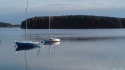
Zalew Wilcza Wola- Zalew Maziarnia - Zbiornik Łęg.
To przepiękne miejsce zlokalizowane na terenie gminy Raniżów i Dzikowiec. Z dwóch stron otoczony lasem zalew pozwala cieszyć się dziką naturą i spokojem,
Ścieżka Edukacyjno Wypoczynkowa wokół zalewu ma długość 3,5 km, spokojne przejście zajmuje 2 godziny. Trasa prowadzi przez dziewięć przystanków przedstawiających leśną przyrodę.Ścieżka ma charakter informacyjny.

Zalew jest zbiornikiem zaporowym na rzece Łęg.
Pojemność całkowita zbiornika: 3,83 mln m³.
Powierzchnia 1,6km² ( 160ha).
Zbiornik powstał w wyniku przegrodzenia doliny rzeki Łęg zaporą w 1989r. Zbiornik pełni wiele funkcji min. zaopatrzenie w wodę, irygacyjną, gospodarstwa stawowego, rekreacyjną oraz retencyjną,

Jak dojechać na miejsce?

W miejscowości Wilcza Wola na wysokości Izby Rybka znajduje się bezpłatny parking. Znajduje się on ok 500 metrów od początku zapory.

Parking:

N 50°20.620

E021°56.198

Kolejny parking znajduje się tuż przy zaporze lecz w sezonie letnim jest płatny.

Caches in this GeoPath Zalew Wilcza Wola

include following caches in gpx file:


inactive
ignored
placed by you
watched
founded
Logs count in gpx file*: 5

*) - for each cache. Available only for "GPX" files OK
information
Statistics for this GeoPath Zalew Wilcza Wola
Your progress on this GeoPath


0% (You found 0 from 9 Caches in the Geopath)

Show more statistics

Opinions and comments

Log your visit