
 First you need to find {CFrequirment} Caches to create a new GeoPath
|
GeoŚcieżka - Do Wojdy | ||
|
|
|||
| GeoPath details | |||
| Mentor (?) |
grafen | ||
| Completed | 36 times | ||
| Scoring | 224.22 Points | ||
| Number of caches | 33 (0 / 0 / 0) | ||
| % cache finds required to complete GeoPath | 90% ( Geocaches) | ||
| GeoPath type | Thematic | ||
| Publication date | 08-06-2019 | ||
| Owners | grafen | ||
| GeoPath's description | |||
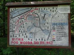
GeoŚcieżka - Do Wojdy, jest ścieżką historyczno - przyrodniczą. W opisach skrzyneczek zawarta jest historia Powstania Zamojskiego jak równiez opisy przyrodnicze Roztocza.
GeoŚcieżka ma około 6 km długości i wyznaczona jest od miejscowości Szewnia Dolna do Wojdy i od Wojdy do Szewni Dolnej.Pętla GeoŚcieżki zamyka sie w tym samym miejscu, gdzie można pozostawić pojazd. Od Szewni Dolnej do Wojdy GeoŚcieżka oznakowana jest białymi kwadratami z ukośnym czerwonym paskiem po przekątnej, natomiast od Wojdy do Szewni Dolnej prowadzi zielonym szlakiem pieszym.
Na trasie GeoŚcieżki zainstalowanych jest 33 keszy - pojemniki PET- w leśnym maskowaniu.
GeoŚcieżka dostępna jest dla rowerzystów jak również dla piechurów.
W okresie letnim, należy być przygotowanym na kleszcze i komary.
GeoŚcieżka przebiega przez kompleks lasów Roztoczańskiego Parku Narodowego, przypomina się o przestrzeganiu Regulaminu Parku oraz Ustawy o Ochronie Przyrody i Środowiska.
Właściciel GeoŚcieżki posiada pozwolenie Dyrekcji Parku na instalacje skrzynek na terenie RPN.
Życzę miłych wrażeń krajoznawczych, podczas odwiedzania skrzyneczek geosachingowych.
Reaktywacja skrzyneczek, po uzyskaniu zgody przez Ojca założyciela.
| Caches in this GeoPath GeoŚcieżka - Do Wojdy |

|


| Opinions and comments |


