Największy na świecie niekomercyjny serwis geocachingowy
GeoŚcieżki - skupiające wiele keszy
Ponad 1000 GeoŚcieżek w Polsce!
Pełne statystyki, GPXy, wszystko za darmo!
Powiadomienia mailem o nowych keszach i logach
Centrum Obsługi Geokeszera wybierane przez Społeczność
100% funkcjonalności dostępne bezpłatnie
Przyjazne zasady publikacji keszy
geocache GeoPaths
GeoPath name
GeoPath type What is this?HelpHelpSpecifies the type of GeoPath. If the majority of caches are arranged in a line, or form a design on the map, set Geo-sketch . If the majority of caches highlight a tourist attraction (e.g. a famous building, museum, etc.) set Touristic . If the majority of caches show off a natural feature (e.g. a mountain peak, viewpoint, etc.) set Nature . If the caches have a common theme (e.g. cathedrals, famous authors, etc.) set Thematic . If you think your GeoPath should be in another category which is not listed, contact the OC Team cog (at) opencaching.pl
% cache finds required to complete GeoPath
What is this?HelpHelpAfter logging a percentage of the caches, the user may log the GeoPath as completed
GeoPath Description

Start a new GeoPath
Waypoint Cache name belongs to GeoPath  
(No caches to display)
GeoPaths
Number of displayed GeoPaths: {displayedPowerTrailsCount} Display options
Name Type {statusOrPoints} Publication date Number of caches Completed


[BP] Biała Przemsza

GeoPath details
Mentor (?)HelpMentorThe mentor is the person who created the GeoPath. mangus i 27@
Visibility
Completed 15 times
Scoring 120.56 Points
Number of caches 18 (0 / 0 / 0)
% cache finds required to complete GeoPath 100% ( Geocaches)
GeoPath type Nature
Publication date 04-06-2022
Owners mangus i 27@
GeoPath's description

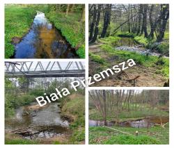
Biała Przemsza – rzeka w województwie małopolskim i śląskim, biorąca początek na Wyżynie Krakowsko-Częstochowskiej. Ma długość 63,9 km i zlewnię o powierzchni 876,6 km².

Rzeka tworzy odnogi, meandry, moczary, niekiedy stawy. Przepływy i stany wód są bardzo stałe.

W latach 1796–1806 Biała Przemsza stanowiła rzekę graniczną pomiędzy Nowym Śląskiem Królestwa Prus a Monarchią Habsburgów, a w latach 1815–1914, na odcinku od Sławkowa do Maczek, pomiędzy Królestwem Galicji i Lodomerii Austro-Węgier a Królestwem Polskim Imperium Rosyjskiego. W przeszłości była rzeką spławną. M.in. w latach 1826–1831 transportowano nią blachę i odlewy z walcowni pod Sławkowem do portu rzecznego w Niwce. Do 1839 r. kursował po Białej Przemszy zbudowany przez Anglika Davy’ego parowiec, zwany przez mieszkańców nadbrzeżnych wiosek czortopchajem. Po rzece kursowały też w XIX w. mniejsze galary przewożące aż do ujścia Przemszy do Wisły produkty rolnicze i węgiel kamienny. 

Zapraszam na małą wycieczkę w miejsca bardziej i mniej znane.

Caches in this GeoPath [BP] Biała Przemsza

include following caches in gpx file:


inactive
ignored
placed by you
watched
founded
Logs count in gpx file*: 5

*) - for each cache. Available only for "GPX" files OK
information
Statistics for this GeoPath [BP] Biała Przemsza
Your progress on this GeoPath


0% (You found 0 from 18 Caches in the Geopath)

Show more statistics

Opinions and comments

Log your visit