

Zobacz statystykę skrzynki
Ujście Suchszego dopływu Suchej do... Suchej - OP341B
dwie mazowieckie rzeczki
Właściciel:
meteor2017
 Zaloguj się, by zobaczyć współrzędne.
 21x znaleziona
  2x nieznaleziona
  7 komentarze
  4 obserwatorów
  Oceniona jako: dobra
 1 x rekomendowana
Skrzynka rekomendowana przez:
Kubash


Musisz się zalogować,
aby zobaczyć współrzędne oraz
mapę lokalizacji skrzynki
aby zobaczyć współrzędne oraz
mapę lokalizacji skrzynki
 Atrybuty skrzynki


 Opis
Opis
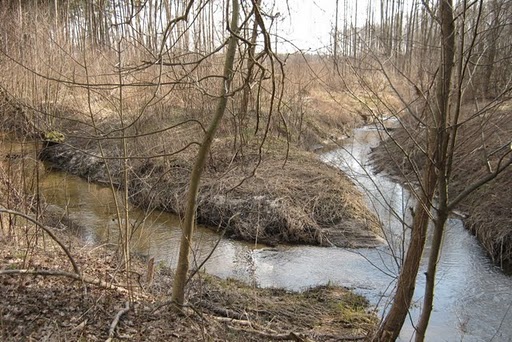
Jest to miejsce, gdzie bezimienna mazowieczka rzeczka nazywana przeze mnie roboczo Suchszym dopływem Suchej wpada do drugiej mazowieckiej rzeczki, czyli Suchej (pseudonim artystyczny Nida).
Miejsce trochę zakrzaczone, pokrzywy też już kiełkują, polecam więc atak wczesną wiosną, czy późną jesienią... latem natomiast koniecznie w długich spodniach. Gdy skrzynka była zakładana, bobry tutaj jeszcze nie bobrowały, ale teraz jest tu mnóstwo śladów ich działalności, min. tama na rzeczce obok skrzynki.
 Dodatkowe informacje
Musisz być zalogowany, aby zobaczyć dodatkowe informacje.
 Obszary ochrony przyrody
| Prawdopodobnie skrzynka znajduje się na obszarze: | |
| Bolimowski Park Krajobrazowy |

|
 Obrazki/zdjęcia

 Wpisy do logu:
21x
2x
7x
Wpisy do logu:
21x
2x
7x


