Największy na świecie niekomercyjny serwis geocachingowy
GeoŚcieżki - skupiające wiele keszy
Ponad 1000 GeoŚcieżek w Polsce!
Pełne statystyki, GPXy, wszystko za darmo!
Powiadomienia mailem o nowych keszach i logach
Centrum Obsługi Geokeszera wybierane przez Społeczność
100% funkcjonalności dostępne bezpłatnie
Przyjazne zasady publikacji keszy
geocache GeoPaths
GeoPath name
GeoPath type What is this?HelpHelpSpecifies the type of GeoPath. If the majority of caches are arranged in a line, or form a design on the map, set Geo-sketch . If the majority of caches highlight a tourist attraction (e.g. a famous building, museum, etc.) set Touristic . If the majority of caches show off a natural feature (e.g. a mountain peak, viewpoint, etc.) set Nature . If the caches have a common theme (e.g. cathedrals, famous authors, etc.) set Thematic . If you think your GeoPath should be in another category which is not listed, contact the OC Team cog (at) opencaching.pl
% cache finds required to complete GeoPath
What is this?HelpHelpAfter logging a percentage of the caches, the user may log the GeoPath as completed
GeoPath Description

Start a new GeoPath
Waypoint Cache name belongs to GeoPath  
(No caches to display)
GeoPaths
Number of displayed GeoPaths: {displayedPowerTrailsCount} Display options
Name Type {statusOrPoints} Publication date Number of caches Completed


Rzeka Reda

GeoPath details
Mentor (?)HelpMentorThe mentor is the person who created the GeoPath. woyt
Visibility
Completed 12 times
Scoring 127.51 Points
Number of caches 16 (0 / 0 / 0)
% cache finds required to complete GeoPath 75% ( Geocaches)
GeoPath type Nature
Publication date 16-04-2018
Owners woyt
GeoPath's description

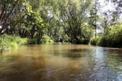
     Przepływająca przez Wejherowo rzeka Reda to wspaniała i miejscami bardzo dzika rzeka.Wędrując jej brzegiem ,patrząc na płynąca wodę i otaczająca przyrodę można zapomnieć ,ze znajdujemy się tak blisko cywilizacji.Moje liczne wyprawy wędkarskie pozwoliły mi dobrze poznać jej bieg i odkryć mnóstwo ciekawych miejsc .Niektóre z nich ma przybliżyć ta seria keszy. 


    Kolejność zdobywania jest  dowolna.Numery skrzynek to tylko kolejność w jakiej robiłem maskowania,      znajdowałem na nie miejsca ,drukowałem logbooki itd.


    Ponieważ z kordami rożnie bywa podaje na którym brzegu znajduje się skrzynka.

   zgodnie z biegiem rzeki:

   lewy brzeg-LB

  prawy brzeg-PB

  Nr.1-PB                                       Nr.6-PB                                       Nr.11-LB

  Nr.2-PB                                       Nr.7-LB                                       Nr.12-LB

  Nr.3-PB                                       Nr.8-LB                                       Nr.13-LB                              Nr.16-atakujemy z PB     

  Nr.4-LB                                       Nr.9-LB                                       Nr.14-LB

  Nr.5-LB                                       Nr.10-LB                                     Nr.15-PB


Na teren gdzie są skrzynki nr.7,9,10,11 najlepiej wejść od strony gdzie znajduje się nr.11 ona robi za drogowskaz.Można też od strony lądowiska dla śmigłowców przy szpitalu omijając kanał.Nie polecam dojścia od północy.

Wskazane jest tam solidne obuwie szczególnie po deszczach.

Ciężki teren może też być w okolicach skrzynki nr .12


  Życzę powodzenia i miłej zabawy.


Caches in this GeoPath Rzeka Reda

include following caches in gpx file:


inactive
ignored
placed by you
watched
founded
Logs count in gpx file*: 5

*) - for each cache. Available only for "GPX" files OK
information
Statistics for this GeoPath Rzeka Reda
Your progress on this GeoPath


0% (You found 0 from 16 Caches in the Geopath)

Show more statistics

Opinions and comments

Log your visit